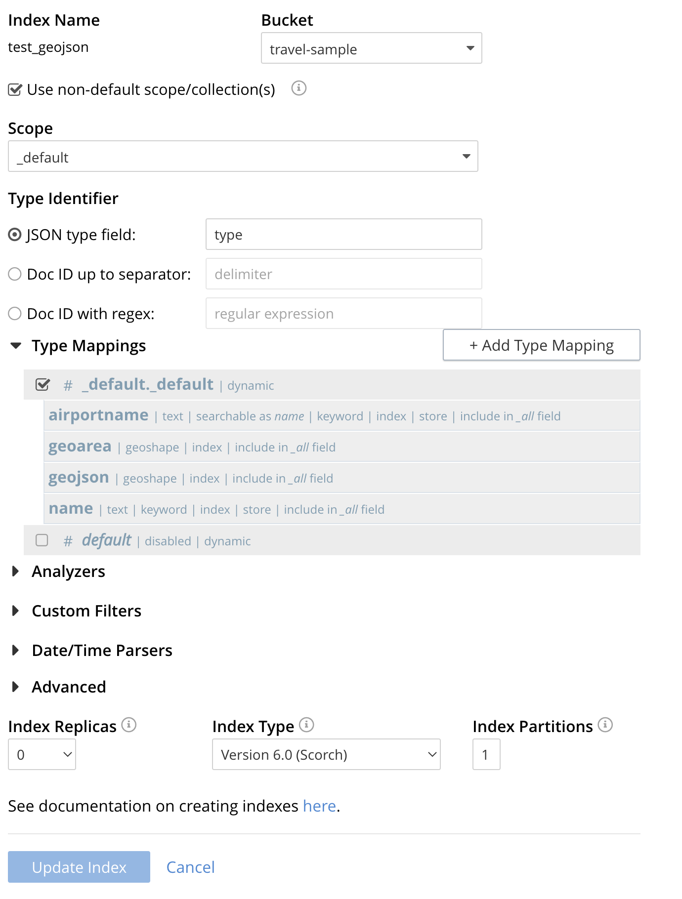
Creating a GeoJSON Index via the REST API
This example quickly creates the final index (able to sort by keyword) as found in Creating a Geospatial Index (type geojson) in Geospatial GeoJSON Queries.
In order to run this example there is a required data modification for travel-sample refer to the "Prerequisites - Modify the travel-sample dataset" section in Geospatial GeoJSON Queries.
|
The cURL command below was initially created via the Classic Editor in the UI, however the follwoing modifications were made.
-
The curl flag "-s" to suppress some runtime output.
-
The credentials "-u <username>:<password>" were altered to "-u ${CB_USERNAME}:${CB_PASSWORD}".
-
The hostname or IP address was replaced with ${CB_HOSTNAME}.
-
The commands output is piped through the utility jq to enhance readability.
-
The two (2) UUIDs were removed (similar to the below) because we want to make a new index not modify an existing one.
  "uuid": "273a60635f5248e5",
  "sourceUUID": "2b421d183cb76aebbffa45424736ec2e",
The Creation Command
The full command to create the index is below and can be executed verbatim if you have the environment variable ${CB_USERNAME}, ${CB_PASSWORD} and ${CB_HOSTNAME} set.
curl -s -XPUT -H "Content-Type: application/json" \
-u ${CB_USERNAME}:${CB_PASSWORD} http://${CB_HOSTNAME}:8094/api/index/test_geojson -d \
'{
  "type": "fulltext-index",
  "name": "test_geojson",
  "sourceType": "gocbcore",
  "sourceName": "travel-sample",
  "planParams": {
    "maxPartitionsPerPIndex": 1024,
    "indexPartitions": 1
  },
  "params": {
    "doc_config": {
      "docid_prefix_delim": "",
      "docid_regexp": "",
      "mode": "scope.collection.type_field",
      "type_field": "type"
    },
    "mapping": {
      "analysis": {},
      "default_analyzer": "standard",
      "default_datetime_parser": "dateTimeOptional",
      "default_field": "_all",
      "default_mapping": {
        "dynamic": true,
        "enabled": false
      },
      "default_type": "_default",
      "docvalues_dynamic": false,
      "index_dynamic": true,
      "store_dynamic": false,
      "type_field": "_type",
      "types": {
        "_default._default": {
          "dynamic": true,
          "enabled": true,
          "properties": {
            "airportname": {
              "dynamic": false,
              "enabled": true,
              "fields": [
                {
                  "analyzer": "keyword",
                  "include_in_all": true,
                  "index": true,
                  "name": "name",
                  "store": true,
                  "type": "text"
                }
              ]
            },
            "geoarea": {
              "dynamic": false,
              "enabled": true,
              "fields": [
                {
                  "include_in_all": true,
                  "index": true,
                  "name": "geoarea",
                  "type": "geoshape"
                }
              ]
            },
            "geojson": {
              "dynamic": false,
              "enabled": true,
              "fields": [
                {
                  "include_in_all": true,
                  "index": true,
                  "name": "geojson",
                  "type": "geoshape"
                }
              ]
            },
            "name": {
              "dynamic": false,
              "enabled": true,
              "fields": [
                {
                  "analyzer": "keyword",
                  "include_in_all": true,
                  "index": true,
                  "name": "name",
                  "store": true,
                  "type": "text"
                }
              ]
            }
          }
        }
      }
    },
    "store": {
      "indexType": "scorch",
      "segmentVersion": 15
    }
  },
  "sourceParams": {}
}'  | jq .
If you successfully create the index you should a response liekt the follwoing
{
  "status": "ok",
  "uuid": "690ac8f8179a4a86"
}
Test the GeoJSON Index with a simple query
Request the first 10 items within the state of Utah (note the query body consistes of simple set of hand drawn set of corner points).
The target-field geojson is specified, to be compared to the query Polygon the target-locations must reside for their documents to be returned.
Don’t worry about newlines when you paste the text.
The results are specified to be sorted on name. Note type hotel and landmark have a name field and type airport has an airportname field all these values are analyzed as a keyword (exposed as name).
curl -s -XPOST -H "Content-Type: application/json" \
-u ${CB_USERNAME}:${CB_PASSWORD} http://${CB_HOSTNAME}:8094/api/index/test_geojson/query \
-d '{
  "query": {
    "geometry": {
      "shape": {
        "coordinates": [
          [
            [-114.027099609375, 42.00848901572399],
            [-114.04907226562499, 36.99377838872517],
            [-109.05029296875, 36.99377838872517],
            [-109.05029296875, 40.98819156349393],
            [-111.060791015625, 40.98819156349393],
            [-111.02783203125, 42.00848901572399],
            [-114.027099609375, 42.00848901572399]
          ]
        ],
        "type": "Polygon"
      },
      "relation": "within"
    },
    "field": "geojson"
  },
  "size": 10,
  "from": 0,
  "sort": ["name"]
}' |  jq .
The output of ten (10) hits (from a total of 18 matching docs) is as follows
{
  "status": {
    "total": 1,
    "failed": 0,
    "successful": 1
  },
  "request": {
    "query": {
      "geometry": {
        "shape": {
          "type": "Polygon",
          "coordinates": [
            [
              [
                -114.027099609375,
                42.00848901572399
              ],
              [
                -114.04907226562499,
                36.99377838872517
              ],
              [
                -109.05029296875,
                36.99377838872517
              ],
              [
                -109.05029296875,
                40.98819156349393
              ],
              [
                -111.060791015625,
                40.98819156349393
              ],
              [
                -111.02783203125,
                42.00848901572399
              ],
              [
                -114.027099609375,
                42.00848901572399
              ]
            ]
          ]
        },
        "relation": "within"
      },
      "field": "geojson"
    },
    "size": 10,
    "from": 0,
    "highlight": null,
    "fields": null,
    "facets": null,
    "explain": false,
    "sort": [
      "name"
    ],
    "includeLocations": false,
    "search_after": null,
    "search_before": null
  },
  "hits": [
    {
      "index": "test_geojson_3397081757afba65_4c1c5584",
      "id": "airport_6999",
      "score": 0.13231342774148913,
      "sort": [
        "Brigham City"
      ]
    },
    {
      "index": "test_geojson_3397081757afba65_4c1c5584",
      "id": "airport_7857",
      "score": 0.27669394470240527,
      "sort": [
        "Bryce Canyon"
      ]
    },
    {
      "index": "test_geojson_3397081757afba65_4c1c5584",
      "id": "airport_7074",
      "score": 0.13231342774148913,
      "sort": [
        "Canyonlands Field"
      ]
    },
    {
      "index": "test_geojson_3397081757afba65_4c1c5584",
      "id": "airport_7583",
      "score": 0.13231342774148913,
      "sort": [
        "Carbon County Regional-Buck Davis Field"
      ]
    },
    {
      "index": "test_geojson_3397081757afba65_4c1c5584",
      "id": "airport_3824",
      "score": 0.24860341896785076,
      "sort": [
        "Cedar City Rgnl"
      ]
    },
    {
      "index": "test_geojson_3397081757afba65_4c1c5584",
      "id": "airport_7581",
      "score": 0.13231342774148913,
      "sort": [
        "Delta Municipal Airport"
      ]
    },
    {
      "index": "test_geojson_3397081757afba65_4c1c5584",
      "id": "airport_8803",
      "score": 0.13231342774148913,
      "sort": [
        "Heber City Municipal Airport"
      ]
    },
    {
      "index": "test_geojson_3397081757afba65_4c1c5584",
      "id": "airport_3614",
      "score": 0.13231342774148913,
      "sort": [
        "Hill Afb"
      ]
    },
    {
      "index": "test_geojson_3397081757afba65_4c1c5584",
      "id": "airport_9279",
      "score": 0.27669394470240527,
      "sort": [
        "Hite Airport"
      ]
    },
    {
      "index": "test_geojson_3397081757afba65_4c1c5584",
      "id": "airport_6998",
      "score": 0.13231342774148913,
      "sort": [
        "Logan-Cache"
      ]
    }
  ],
  "total_hits": 18,
  "max_score": 0.27669394470240527,
  "took": 18446484,
  "facets": null
}